


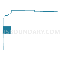
VERMONT - T 1 Voting District, Dane County, Wisconsin
About
Outline

Summary
| Unique Area Identifier | 693147 |
| Name | VERMONT - T 1 Voting District |
| County | Dane County |
| State | Wisconsin |
| Area (square miles) | 35.37 |
| Land Area (square miles) | 35.37 |
| Water Area (square miles) | 0.00 |
| % of Land Area | 99.99 |
| % of Water Area | 0.01 |
| Latitude of the Internal Point | 43.08164590 |
| Longtitude of the Internal Point | -89.78251740 |
Maps

Graphs
Select a template below for downloading or customizing gragh for VERMONT - T 1 Voting District, Dane County, Wisconsin


Neighbors
Neighoring Voting District (by Name) Neighboring Voting District on the Map
- ARENA - T 2 Voting District, Iowa County, WI
- BERRY - T 1 Voting District, Dane County, WI
- BLACK EARTH - T 1 Voting District, Dane County, WI
- BLUE MOUNDS - T 1 Voting District, Dane County, WI
- BRIGHAM - T 3 Voting District, Iowa County, WI
- CROSS PLAINS - T 1 Voting District, Dane County, WI
- CROSS PLAINS - T 2 Voting District, Dane County, WI
- SPRINGDALE - T 1 Voting District, Dane County, WI
Top 10 Neighboring County Subdivision (by Population) Neighboring County Subdivision on the Map
- Springdale town, Dane County, WI (1,904)
- Cross Plains town, Dane County, WI (1,507)
- Arena town, Iowa County, WI (1,456)
- Berry town, Dane County, WI (1,127)
- Brigham town, Iowa County, WI (1,034)
- Blue Mounds town, Dane County, WI (968)
- Vermont town, Dane County, WI (819)
- Black Earth town, Dane County, WI (483)
Top 10 Neighboring Unified School District (by Population) Neighboring Unified School District on the Map
- Mount Horeb Area School District, WI (12,121)
- Wisconsin Heights School District, WI (5,876)
- Barneveld School District, WI (2,288)
Top 10 Neighboring State Legislative District Lower Chamber (by Population) Neighboring State Legislative District Lower Chamber on the Map
- Assembly District 79, WI (76,116)
- Assembly District 81, WI (61,347)
- Assembly District 51, WI (57,687)
Top 10 Neighboring State Legislative District Upper Chamber (by Population) Neighboring State Legislative District Upper Chamber on the Map
Top 10 Neighboring 111th Congressional District (by Population) Neighboring 111th Congressional District on the Map
Top 10 Neighboring Census Tract (by Population) Neighboring Census Tract on the Map
- Census Tract 128, Dane County, WI (7,688)
- Census Tract 131, Dane County, WI (4,563)
- Census Tract 127, Dane County, WI (3,867)
- Census Tract 9501, Iowa County, WI (3,753)
- Census Tract 129, Dane County, WI (3,746)